
BY TOM LEE
The small town of Stellenbosch is known for being a hub of constant activity, hustle and bustle and the occasional outing to the local pub or club. What most people don’t know, however, is that a few of the greatest playgrounds known to man lie just a few kilometres away. The mere mountain trail is all it takes to discover a journey into a world unknown…a world situated twenty minutes from Stellenbosch.
The pressures and constraints of being a student can be overwhelming and sometimes detrimental to the psyche. One of the best ways to ease tension and enjoy oneself to the fullest is to set out on a hike of any distance or difficulty.
The geology that surrounds Stellenbosch provides for some of the most magnificent mountaineering trails and summits in the Western Cape. The Stellenbosch mountain, Jonkershoek valley and Franschhoek mountains, especially, can become settings for an awesome day, or even night, out in the Boland wilderness. Put on your hiking boots and tighten the straps on your backpack. Our guide to the top three hikes in the greater Stellenbosch area will have you beating about the bush in no time.
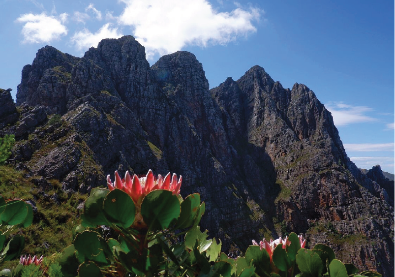
Photo: Tom Lee
Stellenbosch Mountain
The first of these hikes is known by many a student. However, few are aware of the lonesome trial and contour path that runs up the north facing slope of the Stellenbosch Mountain. Starting at Coetzenburg rugby fields, the hiking trail shoots up past the first cross and begins to hairpin up the face of the mountain. This well-maintained path contours up towards the second cross and finds itself dipping down into a two-hundred-meter plateau.
Many confuse this initial summit as being the end of the road. Don’t be fooled – it is merely a means to an end. The summit continues as one begins to traverse across the south side of the mountain with a view of Table Mountain, Newlands Ravine and the greater False Bay area. The rocky outcrop at the top of the climb will indicate that you are nearly at journey’s end. Be on the lookout for the trig beacon that indicates the highest area of the hike.
The way down is rather simple to find but difficult to descend. In order to find the trail down, continue towards the Helderberg mountain reserve and head down Paradyskloof (North West facing slope). This scramble down will end off just above the suburban area of Paradyskloof. You can either walk back through Eden Forest towards Coetzenburg or catch an uber or arranged lift from the suburban area.
Die Pieke
Die Pieke, also known as the twin peaks, is one of the more challenging climbs in the area. This peak is very special to me. The sheer height and aesthetic certainly contribute to my love for it, but the power that the mountain provides to the spirit is like nothing I’ve ever experienced on any mountain in Southern Africa, besides that of the Drakensberg.
The south west facing peak begins at the base of the Jonkershoek Valley and rises up to an elevation of 1494m above sea level. This hike has various routes which one can take. The most appropriate, however, is up Nerinakloof and down Langrivierkloof. This uitstappie goes through both forest canopy, grassland and rocky outcrops and at the summit provides a breath-taking view of the entire Stellenbosch, Pniel, Paarl, CapeTown and False Bay area.
The numerous cliff faces and 200m drops can make the trek daunting at times. However, the satisfaction felt after completing such a climb is well worth the exertion. The descent down Langrivierkloof has some of the best fauna and flora in the Jonkershoek Valley. During this time of year, expect to see a variety of Proteas. The Protea cynaroides, or King Protea is especially magnificent. Various birds of prey, such as black and fish eagles, populate the area and share it with buck like the klipspringer. The beautiful tree canopies and forest vegetation that mark the descent merit an honourable mention and the crystal-clear streams that flow through them are perfect for a dip.
Swartboskloof
The Swartboskloof trail begins in the heart of the Jonkershoek valley. To access it, you will have to make use of the Jonkershoek gate (which will require a R50 entry fee or a wild card) and drive roughly ten minutes to the start of the trail which is situated halfway between the main gate and the start of the first waterfall hike.
The early stages of the hike heads through a flat area of land with beautiful fynbos on either side of the trail. A tough ascent with an elevation gain of 900m follows the 1/2km stroll through the fynbos garden and plateaus at the top. The route from the top of Swartboskloof is straightforward and runs parallel to the source of the Eerste River as it winds its way around towards Guardian Peak.Along this path, the entire Helderberg basin is visible with Somerset West, Sir Lowry’s pass, Strand and Gordons Bay being within sight.
The trail comes to a T-junction with a trail towards Boegoekloof on the right and one to Kurktrekkers to the left. In this instance, the trail down Kurktrekkers is the appropriate and, like the name entails, winding way down towards the first and second waterfall. The hike concludes on the riverside trail that runs alongside the Eerste River towards the beginning of the hike. The total distance is 18km and on average will take 6 hours to complete. The immense joy of completing this hike is what keeps me coming back time after time.